WHAT THIS BLOG IS ALL ABOUT

The objective of this site is to provide YOU, our viewer and prospective client, with meaningful and current information about cruising. It is our intention to bring subjects of interest to you. There are some very interesting articles in the archives. Be sure to click the links to visit the blogs listed there.

We hope to keep you informed, enlightened and entertained.

You are guest number Hit Counterto visit this Blogosphere.

We welcome your comments! Please submit any comments by clicking on the envelope with the right arrow at the end of each posting.

(Counter courtesy of Free Counter)


Wednesday, June 9, 2010

Antarctica – The Last Frontier Part 7

Unfortunately, this will be the last installment of Antarctica – The Last Frontier. Peter and Alice have done a fantastic job in putting the text and photos together for this article. This has been a wonderful journey and I have enjoyed putting it on the internet for you, our clients and potential clients. During this edition, we will experience their post trip adventures in Buenos Aires, Argentina.

Post-cruise in Buenos Aires

The Star Princess docked at 6:30am. When we booked our cruise we prepaid for transfer from ship to the airport where our plane was scheduled to depart at 10:30PM. A few days before we were due to disembark, the tour desk offered post-cruise excursions. Once a passenger selects an excursion, the price prepaid for the airport transfer is credited back to your on-board account and the transfer to the airport is included in the excursion price. What a great value this turned out to be, our excursion was the same price as the prepaid transfer so this was a real deal!

We had seen many of the city sights before the cruise so we decided to do the tour of the Tigre Delta Y Rio de la Plata. The day was perfect for a boat ride along the Rio de la Plata. We boarded a boat that holds about 100 people.

The delta is comprised of more than 5,000 waterways. No cars are used on the islands. All the residents must use a boat to access their house. There is a wide variety of flora and fauna along the way. The river water was certainly murky and we were very surprised to learn it is purified into drinking water. It was interesting to learn the kids are picked up by boat to go to school. Imagine, no school buses just the school boat. If you need a taxi you just call for one, a water taxi. Groceries are delivered by boat or a “grocery boat” pulls along side your dock and you can board it to make your purchase. What a concept, a floating supermarket.

There even was a huge amusement park in one area of the islands. Oh well, that is the end of out cruising experience and we are off to the “holding hotel” where we will board a bus to the airport later in the day.

Our bags were sent directly to a secure spot at the airport. It was a roped off area right before you entered the terminal. We are happy to report our bags were waiting for us when we arrived at the airport at 7:30PM.

One final question --- Do the sinks and toilets run counter clockwise in the southern hemisphere?

Peter and Alice carefully observed sinks on board and on the shore. When we returned home additional research had to be done, since uncertainty still prevailed. The trusty internet uncovered that this is a myth. The particular shape and configuration of the drain is the determining factor in how the water vortex rotates. Some people would like you to believe the Coriolis force is responsible for this shift in direction. The truth of the matter is the Coriolis force is too weak to impact small bodies of water.

Not being a physicist, I’m not even going to try to explain this. Take a look at http://en.wikipedia.org/wiki/Coriolis_effect.

A special message from Peter and Alice:
We wish you beautiful sunrises and sunsets on your next cruise!

Thursday, June 3, 2010

Antarctica – The Last Frontier Part 6

Sooner or later all great cruisess must approach their final stages. This part of Alice and Peter’s adventure takes them into their penultimate port, Montevideo Uruguay. As you will see, Uruguay is a very interesting country rich in history.

Montevideo, Uruguay

Uruguay is the second smallest country in South America. With an area of 68,000 square miles, it is slightly smaller than the state of Washington. This small nation has been the least troubled and consistently democratic of all the countries in South America. The only welfare state in the Western Hemisphere had an early history of bloodshed before the institution of a constitution in 1918.

The constitution laid the foundation for many socialized programs such as eight hour work day, social security for the aged, free medical treatment, free universities and nationalization of almost all essential industries and services. Sound familiar?

It has been said that when explorer Ferdinand Magellan first saw the mountain that overlooks the bay, he turned to his pilot and said in Latin “Monte Videm” (translation indicating secure port guarded by a hill). Today the population of Uruguay is approximately 3.3 million people and Montevideo, the capital of Uruguay, has a population of 1.3 million or a bit less than half of all Uruguayans living there. This chief port city is on the Rio de la Plata which is one of the widest rivers in the world. Most of the residents have roots back to Europe are predominately Spanish or Italian origin. Uruguay is generally not considered a major tourist destination, but visitors from other South American countries come to enjoy the beaches.

While in this port we decided to take the city highlight tour. We drove along the Rambla, the name given to any street that follows the shoreline. While traveling along the shore line take special note of the changing color of the water. If the water comes from the ocean it is blue and salty. If it is brown it is fresh water. From the looks of the brown areas, I would prefer to swim where it was blue.

Throughout the city one will see pink blooming trees that are called Hawaiian Orchids. Our tour was in the early morning and there were many groups on the beach practicing Tai Chi. Most people own a dog or may own several. Typical species are Golden Retrievers, Beagles or Rottweilers. In the summer dogs are not allowed on the beaches. Dog walking has become a big business.

During our tour we saw people holding what looked like a small round bowl which was a calabash gourd and sipping from a traditional silver straw or bombilla in Spanish. This caffeinated national drink is called Maté (mah-tay). Since the bombilla is considered to be a personal item that may be shared by many in a home environment, you cannot order one in a restaurant. Some of the gourds are quite handsomely decorated. They are covered with leather and decorated with silver. The Yerba maté (Ilex paraguariensis) is a medium-sized evergreen tree with leaves similar to holly that are stiff and leathery. The yerba leaves are dried, chopped and ground into a powder. Hot steaming water is continuously poured over the leaf powder during the day. The bombilla acts as a straw and sieve with small holes at the bottom that allows you to drink the brewed liquid. We were told it is an acquired taste, since the liquid is quite strong and bitter. They apparently are not worried about passing germs among friends with so many people using the same bombilla.

Some of the sights we saw were:

The Legislative Palace


Belloni’s sculpture La Carreta (Covered Wagon)


The Estadio Centenario, the 85,000 seat futbol (soccer) stadium. This stadium was built 1930 for the first world cup soccer matches. Remember, soccer (Futbol) to the rest of the world is like baseball to Americans. It’s almost a religion.

We traveled through the exclusive Prado neighborhood with many big beautiful homes. We learned that adult children stay at home until they are about 30. Most couples have 1-2 children; thus, the population increase is only 0.3% per annum.

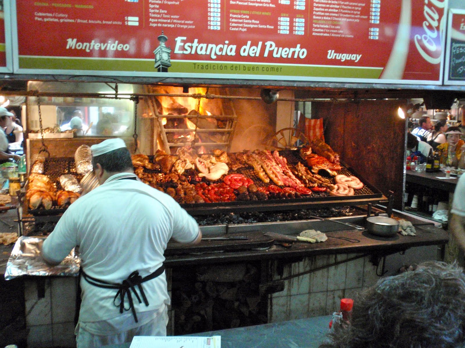
If it is around lunch time you might want to consider having lunch at Mercado del Puerto. It is a short walk from the pier. In 1868 it was the center of Uruguay's trading activity. Once you step inside this wrought iron structure with the sky lit roof you are reminded of an old railway station. The aisles were narrow to say the least, but we were able to move with the crowds who were looking to find a seat at one of the reasonable priced parrillas (steak houses). After a great lunch, we made our way out of the market place to the surrounding street where we located and purchased our traditional take homes, shot glasses and spoons souvenirs.

Be sure to read the next and final installment of Antarctica – The Last Frontier when we wrap up next time with Post Cruise in Buenos Aires.

Wednesday, May 26, 2010

Antarctica – The Last Frontier Part 5

During this part of our Antarctic journey with Peter and Alice we visit Ushuaia, the southernmost city in the world. Located in a wide bay on the southern coast of the island of Tierra del Fuego, the city is bounded on the north by the Martial mountain range and on the south by the Beagle Channel.

Ushuaia (Isla Grande - Tierra del Fuego), Argentina
Pronunced - ooo-shoo-AYE-ah, the capital city's name comes from the Yahgan Indians (canoe people) meaning “a bay of penetration westward”. Tierra Del Fuego is an island meaning Land of Fire. The Andes Mountains run north – south while the city runs east-west. Chile is Ushuaia’s neighbor on the other side of the Andes Mountains. Ushuaia has the distinction of being called “Fin del Mundo” (end of the world), since this is where the Pan American highway route that begins in Alaska ends.
We took a scenic mountain bus tour of the Olivia River Valley through Carbajal Valley and climbed the Alvear Range to Garibaldi Pass. At this point we had a beautiful view of Hidden Valley Lake.
Our tour guide was ecstatic about the weather we were having during our visit. She kept on apologizing for commenting so often that it is such a beautiful sunny day with ideal temperature. The scenery was breathtaking with snow capped mountains surrounding us everywhere.

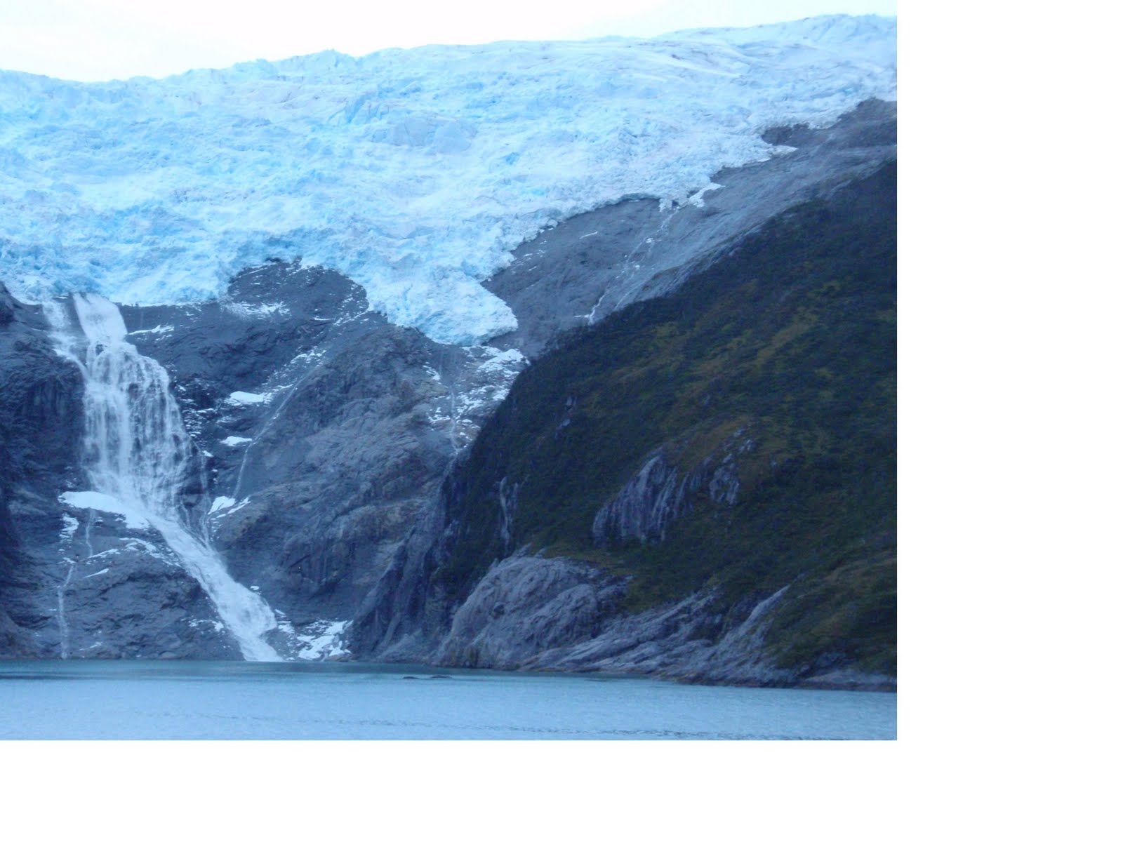
That evening when we sailed away from Ushuaia, the Beagle Channel was as smooth as glass with no wind and only soft ripples in the water. The stillness was similar to an experience we had looking over the Grand Canyon. In the background were smoky glistening mountains. As we were sitting in the Crown Grill Steakhouse having dinner, we slowly passed by huge waterfalls cascading down the huge glaciers. The views were spectacular!

Punta Arenas (Sandy Point), Chile

The city of Punta Arenas lies atop rolling hills, overlooking the Strait of Magellan. Today it remains a prosperous town due to the richness of natural resources. It is also the gateway to Chilean Patagonia with its maze of fjords, and rivers and mountains to the north. To the south lies the great frozen mass of Antarctica.

We took a city highlight tour which included a visit to the open air exhibition at the Patagonia Museum. This certainly was a different type of museum. There was very old farm equipment staged all around in an open area. In one of buildings you saw the equipment and setup used to shear sheep. Wool was really big back then, but now New Zealand and Australia dominate the wool market. Another building housed a few antique cars (Fords) including the containers of gasoline used to fuel the cars. Yet another building housed a very old dentist's office complete with his chair and equipment. Chile produces oil but does not have sufficient oil or refining capacity to make them exempt from importing additional oil. Another building was comprised of rooms seen in a typical house. The ceilings were not that high and the furniture used during that period was not elaborate nor were there many pieces. The biggest stand alone building had numerous rooms where you could look at a typical theater with movie equipment and theater seats. One room was a fully equipped dental office. The pharmacy had cabinets to the ceiling filled with the various potions of the day.

Our next stop was at the Maggiorino Borgatello Museum housed in a 19th century mansion. There is a lot of natural history to absorb. We can say that we have come away from this cruise with a better appreciation of nature with all of its differences.

We stopped at the Pioneer Cemetery with its many beautifully manicured cypress trees. Near the entrance was a mausoleum for the Grimaldi family. Prince Albert of Monaco stopped here to pay his respects to his family before he started his Antarctica expedition. Who knew this family of Monaco had roots in Chile? This cemetery is certainly different than Recoleta Cemetery in Buenos Aries where Evita Peron is buried. The Pioneer cemetery is segregated by nationality. Both cemeteries have mausoleums with magnificent architecture.
Instead of returning directly to the ship we had the bus driver drop us off in the center of town, since it was just a short walk back to the ship. We walked through the craft fair in the park. Many tourists were gathered around the Magellan Statue with the unknown Indian. The toe of the Indian is very shiny, since many people kiss his toe. The theory is that if you kiss the toe you will have a safe passage on your next sea journey. Imagine all of those germs?

Next: Montevideo, Uruguay

Monday, May 17, 2010

Antarctica – The Last Frontier Part 4

Moving right along with our Antarctic exploration dream, we follow our authors and photographers, Alice and Peter leisurely cruising through straits, islands, archipelagos and peninsulas.


Cruising the Antarctica Peninsula - February 9, 2010

During the night our ship continued southwest through the Bransfield Strait headed toward Anvers Island. Early in the morning we entered one of the main attractions of Antarctica, the Gerlache Strait. As the ship leisurely cruises along, we felt as if we were ice bound by the mountains on both sides. Our ship slowly maneuvered between the islands of the Trinity Peninsula on the port side and the land mass with high mountains of Palmer Archipelago on the starboard side. We saw what we thought was pink snow. This seasonal phenomenon really was algae that live on the snow. The spray from the sea combined with the nutrients (or more mildly put “poop”) from the penguin colonies enable the algae to grow. The color of the algae can be pink, red or green. After lunch we passed Wiencke Island as we entered the Bismarck Strait to make a right turn into Neumayer Channel. Over the loud speakers came the voice of Capt Perrin advising us to “hold on”. Winds of 80 knots (66.7 miles per hour) were coming across the bow as we started our turn. The ship listed to the port side, then the starboard, and then the port side again. Passenger safety is always the captain’s main concern. The decision was made to skip the Newmayer Channel and exit the Gerlache Strait the same way we had just traveled. The port side views were different than the ones we saw in the morning. We saw Wiencke Island, the peaks of Mt Francais on Anvers Island, and Lion Island.

In the Neumayer Channel we would have seen deep cut fjords with a glacier that is 8 miles long and 2 miles wide flowing along the Allardyce Range. The mountains rise straight up from the water appearing like sea cliffs. The channel is shaped like an “S”. Since the channel is so narrow, there are times where there appears to be no visible exit.

Look carefully at the photo below and you can see the MS Bremen in the middle of the photograph cruising in the bay close to the shoreline. (Click the picture itself for a better view. Click on your back arrow to resume.) In order to appreciate the height of the surroundings, take note of the size of ship in relationship to the mountains and glaciers.


February 10, 2010 - Deception Island

At 7am the weather was cloudy as we viewed the mouth of Deception Island. This island is ring shaped with an internal crater that is almost 8 miles in diameter. Smaller ships are able to enter the mouth of this natural harbor (Whalers Bay) to explore this collapsed volcano filled with water. Deception Island is considered one of the largest crater islands in the world. The volcanic rock has huge iron deposits on the rocks that provide a colorful array in the sunlight. In 1969 the British and Chilean research stations were destroyed by a volcanic eruption.

The beaches and waters of the island are home to Weddell and crab eating seals, as well as Gentoo and Chinstrap penguins. On the towering brown cliff of Bailey Head thousands of Chinstrap penguins nest as far as 600 feet up the side of the mountain. It is a long walk for them to reach the beach for food, but the ice is thinner higher on the side of the mountain enabling chicks to hatch sooner than on the beach. This timing could mean life or death for a chick. The white dots on the black shore are penguins.


Large amounts of “bergs” are blown here by northern winds. We enjoyed the varieties of icebergs that the seas presented to us. Each iceberg has its own “DNA.” Like snowflakes, no two icebergs are identical. The blue striation of color throughout the iceberg is a beautiful sight. Like glaciers, light reflects differently through the iceberg. If the weight of snow forced oxygen to be released they become bluer. You can tell the age of a berg by its color. The young ones are always bright white while the dark blue ones are very old. The largest of the bergs is an Ice Land that could be the size of a small city of several thousand square miles. Our ship dwarfed some of these tall icebergs. As the size of the iceberg decreases over time they turn into Tabular Icebergs (100 to 150 feet high) with flat tops. Pieces break off the Tabular Icebergs to form Bergy Bits in various shapes and sizes with jagged edges and spiraling columns formed by the winds and waves. Tomorrow our journey of viewing natural formations of land and ice is coming to an end as we enter the Drake Passage to circumnavigate Cape Horn.

February 11, 2010 - Cape Horn Cruising

During the night we headed North-North West through the turbulent waters of Drake Passage. We can say we passed over the Antarctic Convergence or Polar Front. This is a shifting liquid boundary where cold dense water is moving north toward warmer water from the Atlantic and Pacific. We sailed from the Atlantic Ocean into the Pacific Ocean and then back into the Atlantic again.

When we arrived in close proximity to Cape Horn the weather was clear but the seas were rough with huge waves. The Chilean pilot, who is required to guide us as we circumnavigate around Cape Horn Island, was unable to travel the 9 miles in his small boat to join our team on the bridge. Who knew that this southern most tip of South America is really an island that is part of the Tierra del Fuego archipelago of southern Chile? Today 1400 feet above sea level there is a Chilean military outpost that controls all of the traffic in the area.

When Sir Francis Drake circumnavigated the world in 1578 he reported the existence of a wide open ocean south of the Straits of Magellan. On January 29, 1616 two Dutch navigators, Jakob Le Maire and Willem Schouten sailed the Eendracht through “Cape Hoorn”, the southern most tip of South America. This island is part of the Tierra del Fuego archipelago of southern Chile. The island was named after Hoorn, Holland where Schouten was born. At that time it was very important to discover another route to the East Indies, since the East India Company’s charter did not allow any other Dutch trading company to use the Straits of Magellan or Africa’s Cape of Good Hope to reach the East Indies.

In 1848 gold was discovered at Sutter's Mill, California. Cape Horn became the passageway from the Atlantic to the Pacific coast. By 1869 the transcontinental railroad became the safer and quicker means to cross North America than the dangerous prairie. In 1914 the opening of the Panama Canal caused traffic around Cape Horn to decline even further.

Many lives have been lost in these waters due to 65 foot waves, gale storms that occur 200 days per year with 130 days per year of heavy clouds. The temperature most of the year is cold. Today the seas were rough, but the weather was clear. With our binoculars we could see the chapel and lighthouse sitting on top of the brown cliffs of granite. We could also see the cast aluminum monument with a cut-out representing an albatross in flight. This monument was erected in 1992 as a memorial for all the sailors who have perished undertaking the treacherous voyage rounding the Cape. As one approaches the Cape Horn Memorial he can read the incription and understand the significance of the albatross.

The Cape Horn Memorial Inscription reads:

I, the albatross that awaits at the end of the world...I am the forgotten soul of the sailors lost, rounding Cape Horn from all the seas of the world. But die they did not in the fierce waves, for today towards eternity, in my wings they soar, in the last crevice of the Antarctic winds.

Next: Ushuaia (Isla Grande Tierra del Fuego), Argentina